Sentinel-2 Bands at Level-1 and Level-2: Wavelengths, Uses, and Comparisons
2025-08-07 · 6 min read · Sentinel-2 · TOA · BOA · Landsat · Bands

TL;DR: Sentinel-2 MSI has 13 bands from coastal blue to shortwave infrared at 10, 20, and 60 m. Level-1C is top-of-atmosphere reflectance, Level-2A is bottom-of-atmosphere surface reflectance. For most cross-date analytics compute on Level-2A, for time-critical or difficult scenes Level-1C can be more stable. Three red-edge bands and a narrow NIR are Sentinel-2 strengths compared with many other missions.
Level-1C vs. Level-2A in one paragraph
Level-1C is radiometrically calibrated top-of-atmosphere reflectance tiled in UTM. Level-2A is surface reflectance derived from Level-1C with atmospheric correction and quality layers, delivered at the same native pixel sizes. Use Level-2A when you want comparability across dates and scenes. Use Level-1C when you need lowest latency or expect the correction to struggle in snow, aerosols, or very low sun. Read more: Copernicus Sentinel-2 mission overview
Sentinel-2 bands at a glance
The table lists typical central wavelengths and native resolutions. Values are representative for Sentinel-2A and 2B.
| Band | Center (nm) | Native res | What it is useful for |
|---|---|---|---|
| B1 Coastal aerosol | 443 | 60 m | Aerosol and coastal water corrections, high-altitude haze context |
| B2 Blue | 490 | 10 m | Bathymetry in clear water, true-color composites, turbidity |
| B3 Green | 560 | 10 m | Vegetation vigor, green peak, suspended matter |
| B4 Red | 665 | 10 m | Chlorophyll absorption, indices with NIR |
| B5 Red-edge 1 | 705 | 20 m | Early chlorophyll sensitivity, stress onsets |
| B6 Red-edge 2 | 740 | 20 m | Chlorophyll content and canopy structure |
| B7 Red-edge 3 | 783 | 20 m | Dense canopy discrimination, red-edge indices |
| B8 NIR wide | 842 | 10 m | NDVI, EVI2, biomass proxies |
| B8A NIR narrow | 865 | 20 m | BRDF and aerosol handling, fine canopy signals |
| B9 Water vapor | 945 | 60 m | Water vapor estimation to aid correction |
| B10 Cirrus | 1375 | 60 m | Thin cirrus detection and masking |
| B11 SWIR 1 | 1610 | 20 m | Moisture, burn severity, cloud screening |
| B12 SWIR 2 | 2190 | 20 m | Mineralogy, residue, moisture gradients |
Read more: Sentinel-2 MSI instrument and band set
How Sentinel-2 maps to Landsat 8 and 9
Landsat 8 and 9 OLI/TIRS provide a comparable Blue–Green–Red–NIR–SWIR set, plus a 15 m panchromatic and two thermal bands. Centers below are rounded for readability.
| Purpose | Sentinel-2 band (nm, res) | Landsat 8/9 band (nm, res) | Notes |
|---|---|---|---|
| Coastal aerosol | B1 443, 60 m | B1 443, 30 m | Similar coastal and aerosol role |
| Blue | B2 490, 10 m | B2 ~482, 30 m | Close analogs |
| Green | B3 560, 10 m | B3 ~562, 30 m | Close analogs |
| Red | B4 665, 10 m | B4 ~655, 30 m | Indices and mapping |
| Red-edge | B5 705, 20 m | — | Sentinel-2 advantage |
| Red-edge | B6 740, 20 m | — | No direct analog |
| Red-edge | B7 783, 20 m | — | No direct analog |
| NIR | B8 842, 10 m | B5 ~865, 30 m | Landsat NIR is slightly narrower |
| NIR narrow | B8A 865, 20 m | — | Useful for BRDF and aerosol handling |
| Cirrus | B10 1375, 60 m | B9 ~1375, 30 m | Thin cirrus detection |
| SWIR 1 | B11 1610, 20 m | B6 ~1610, 30 m | Moisture, burn |
| SWIR 2 | B12 2190, 20 m | B7 ~2200, 30 m | Moisture, residue |
| Panchromatic | — | B8 Pan 15 m | Landsat only |
| Thermal | — | B10, B11 TIRS 100 m | Landsat only |
Read more: Landsat band designations and spectral specifications
Read more: USGS overview of Landsat bands
Where PlanetScope and EarthDaily class sensors fit
Many commercial missions trade broader coverage for fewer or differently placed bands. It helps to compare by band families rather than exact nanometers.
PlanetScope SuperDove class sensors typically offer about eight surface reflectance bands at very high spatial resolution. You will commonly see coastal blue, blue, two greens, yellow, red, a single red-edge near 705 nm class, and one NIR near 865 nm class. There is no SWIR or thermal on this class of sensor. For vegetation monitoring NDVI, EVI2, and basic red-edge signals are available. For moisture or burn severity, the lack of SWIR means you lean on indices built from visible and NIR and you should validate thresholds when porting from Sentinel-2.
EarthDaily constellation class systems are designed for agronomy and environmental monitoring with a richer spectral set than typical eight-band constellations. Public descriptions emphasize multiple red-edge bands and shortwave infrared coverage at meter-class resolution. That means many Sentinel-2 style use cases, including water content and residue mapping, can transfer more directly. Exact centers and counts vary by provider documentation, so treat the comparisons here as a band family guide rather than a specification.
What to use when
For vegetation structure and stress, Sentinel-2’s three red-edge bands plus the narrow NIR improve trait sensitivity and make red-edge indices like NDRE practical. For general crop monitoring, the 10 m Blue, Green, Red, and NIR produce stable NDVI, EVI2, and NIRv when you keep processing consistent. For moisture, burn severity, and residue detection, the SWIR pair B11 and B12 carry most of the signal. When porting to Landsat, match band purposes, not exact centers, then validate breakpoints. When moving to PlanetScope class data, expect strong performance for visible and NIR indices and plan around the absence of SWIR. When moving to EarthDaily class data, look for multiple red-edge and SWIR coverage that can preserve more of your Sentinel-2 feature set.
Practical notes on resolutions and consistency
Sentinel-2 10 m bands are B2, B3, B4, and B8. Red-edge and SWIR are 20 m. Aerosol, water vapor, and cirrus are 60 m. If you want per-pixel alignment for indices or composites, resample once, set a fixed grid, and hold the processing level constant across dates. Read more: Sentinel-2 product levels and processing
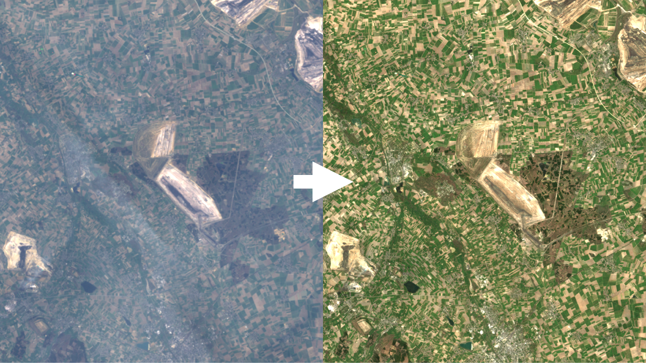
ClearSKY in practice
All ClearSKY deliveries come at 10 m across the stack so bands line up per pixel. Bands that are natively 20 m or 60 m are provided at 10 m using deep learning superresolution or carefully chosen resampling. If you want indices alongside multispectral data, set the Bandnames field in your composite request to include the needed source bands and normalized-difference indices in one go at no additional cost. Use all to receive the full Sentinel-2 style stack, or specify exactly what you need, for example B8,B4,[B8_B4] to return NIR, Red, and a ready to use NDVI layer in one GeoTIFF. You can request Level-1C style inputs for speed or Level-2A style inputs for comparability and keep that choice consistent across a series.